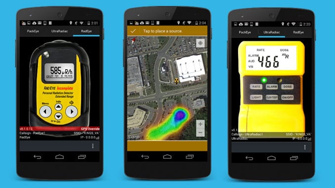
Conceived in the Defense Threat Reduction Agency’s J9 directorate, the Virtual Radiation Training through Ubiety System (VIRTUS) provides realistic, low-cost radiation detection training to military and civilian first responders.
VIRTUS is a suite of Android apps which run on most Android phones and tablets. Simulated radiological dose rates and other measurements are determined based on the Android device’s GPS position. Operators can attach Bluetooth beacons to objects to serve as surrogate radiation sources, facilitating training. Nuclear fallout environments are modeled using standard industry codes.
Ubiety is defined as “the state of being placed in a definite local relation.” Ubiety is foundational to the VIRTUS methodology. Whether through GPS or Bluetooth beacons, VIRTUS determines the relative positioning, or ubiety, of radiation sources and detectors. With this information, detector responses can be simulated.
Four radiation detectors have been simulated in VIRTUS. Handheld systems include the Canberra UltraRadiac™ (AN/UDR-13/14/15) and the Thermo Scientific RadEye™ PRD-ER. These two hip-mounted devices are used by military, first-responder, and industry personnel worldwide.
The Thermo Scientific PackEye™ is a backpack system, and the handheld indicator module (left) has been integrated. The PackEye can detect both γ-rays and neutrons, and the two functionalities are simulated in VIRTUS.
VIRTUS simulates a vehicle-mounted detection system called the Thermo Scientific Mobile Detection System (MDS). The real MDS is housed within a large case, and it includes approximately five liters of scintillating crystals for γ-ray detection, as well as He-3 neutron detector. The system is very sensitive, and it can be mounted within land vehicles and helicopters. The user connects a laptop to the MDS on which a software application called MAPTRACK is used.
In addition to displaying the exposure and count rates of the detectors in the MDS, MAPTRACK also creates a color-coordinated path onto a map of the local area. The colors of the dots along the path correspond to the levels of radiation detected, helping the user to determine geographic “hot zones.” The MAPTRACK interface is simulated within VIRTUS, facilitating vehicle operations training.
VIRTUS distribution is authorized to US military personnel; federal, state, and local first-responders; and selected others. The Defense Threat Reduction Agency maintains the trunk, but the source code is available to government program managers who are free to create a branch.
The VIRTUS project is managed by the Research and Development (R&D) Information Science and Applications Department (J9IS), located at Fort Belvoir, Virginia. J9IS is responsible for the integration and systems engineering of efforts across the R&D directorate. DTRA J9IS manages Technical Reachback a WMD analysis cell that provides 24/7 support to the Department of Defense and the US Government. J9IS is also the technical hub for the Interagency Modeling and Atmospheric Assessment Center (IMAAC), which coordinates and disseminates Federal atmospheric dispersion modeling and hazard prediction products.
VIRTUS is available for download through the DTRA CBRNE Decision Support Site.


